
ParkServe Online Tool - Mapping Your Community's Park Accessibility
Dec. 14, 2017: Over the last five years, building parks has quickly become one of the most popular uses of CPA funds for both cities and towns. It’s not hard to see how a beautiful public park adds to the quality of life for the surrounding community. However, if a park isn’t easily accessible to nearby neighborhoods, it minimizes the overall benefit of the project. Wouldn’t it be helpful to know exactly which areas of your city or town are underserved by parks?
ParkServe® is a new online tool from the Trust for Public Land (TPL) that allows local Community Preservation Committees to target their park funding to the places that need it most. Built as a key component of TPL’s national “10-minute walk” initiative, ParkServe® is an interactive map that allows users to zoom in on a community to analyze its parks and the surrounding neighborhoods. The map provides information about park systems and the associated percentage of community residents living within a 10-minute walk of a park. This percentage can then be further broken down through several demographic lenses, including race/ethnicity, age, and income.
Additionally, the ParkEvaluator™ function is built into the ParkServe® platform and can be accessed by navigating to the "Menu" drop down on the map and clicking "Park Planning." This gives users the ability to immediately see the impact of a potential new park space by drawing in a prospective park on the map. ParkEvaluator™ will then create an updated map displaying how much of the surrounding population would have access to a park within a 10-minute walk. For each city, town, and community, the ParkServe® team has identified optimal potential park sites, showing approximate locations where parks would have the biggest impact on the number of people served.
While not every CPA community is in ParkServe® yet, by next spring most of Massachusetts will be part of the system. If you aren’t in the system yet, but sure to check back next year and see how exactly a new CPA park could impact your community.
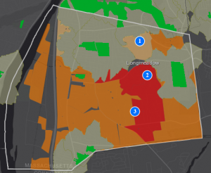 Screenshot of sample ParkServe® map
This map from ParkServe® displays the park accessibility statistics throughout the town of Longmeadow. The orange and red areas on the map indicate that the residents living there are in higher need of park access. The numbered locations indicate where the ParkServe team has identified ideal locations for a new park that would provide the greatest increase of residents served within a 10-minute walk of a park.